concept location in category python

This is an excerpt from Manning's book Math for Programmers: 3D graphics, machine learning, and simulations with Python.
The underlying question is what’s going on underground: where is the oil now and how is it moving? This is a complicated question, but it can also be answered by solving differential equations. The changing quantities here are not positions of a projectile, but rather locations, pressures, and flow rates of fluids underground. Fluid flow rate is a special kind of function that returns a vector, called a vector field. This means that fluid can flow at any rate in any three-dimensional direction, and that direction and rate can vary across different locations within the reservoir.
Even though our everyday experience takes place in three dimensions, it's useful to think of some data as higher dimensional. In physics, it’s common to consider time as the fourth dimension. While an object exists at a location in 3D space, an event occurs at a 3D location and at a specified moment. In data science problems, it’s common for data sets to have far more dimensions. For instance, a user tracked on a website can have hundreds of measurable attributes, which describe usage patterns. Grappling with these problems in graphics, physics, and data analysis requires a framework for dealing with data in higher dimensions. This framework is vector mathematics.
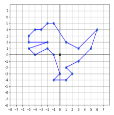
Figure 2.5: Grid lines let us measure the location of points relative to the axes.
class CarForSale():
      def __init__(self, model_year, mileage, price, posted_datetime,
                   model, source, location, description):
          self.model_year = model_year
          self.mileage = mileage
          self.price = price
          self.posted_datetime = posted_datetime
          self.model = model
          self.source = source
          self.location = location
          self.description = description

This is an excerpt from Manning's book Hello World! Third Edition.
Listing 10.1. Skier
import pygame, sys, random
skier_images = ["skier_down.png", "skier_right1.png",
               "skier_right2.png", "skier_left2.png",
               "skier_left1.png"]

class SkierClass(pygame.sprite.Sprite):                             #1
    def __init__(self):                                             #1
        pygame.sprite.Sprite.__init__(self)                         #1
        self.image = pygame.image.load("skier_down.png")            #1
        self.rect = self.image.get_rect()                           #1
        self.rect.center = [320, 100]                               #1
        self.angle = 0                                              #1

    def turn(self, direction):                                      #2
        self.angle = self.angle + direction                         #2
        if self.angle < -2:  self.angle = -2                        #2
        if self.angle >  2:  self.angle =  2                        #2
        center = self.rect.center                                   #2
        self.image = pygame.image.load(skier_images[self.angle])    #2
        self.rect = self.image.get_rect()                           #2
        self.rect.center = center                                   #2
        speed = [self.angle, 6 - abs(self.angle) * 2]               #2
        return speed                                                #2

    def move(self, speed):                                          #3
        self.rect.centerx = self.rect.centerx + speed[0]            #3
        if self.rect.centerx < 20:  self.rect.centerx = 20          #3
        if self.rect.centerx > 620: self.rect.centerx = 620         #3

class ObstacleClass(pygame.sprite.Sprite):                          #4
    def __init__(self, image_file, location, obs_type):             #4
        pygame.sprite.Sprite.__init__(self)                         #4
        self.image_file = image_file                                #4
        self.image = pygame.image.load(image_file)                  #4
        self.rect = self.image.get_rect()                           #4
        self.rect.center = location                                 #4
        self.obs_type = obs_type                                    #4
        self.passed = False                                         #4

    def update(self):                                               #5
        global speed                                                #5
        self.rect.centery -= speed[1]                               #5
        if self.rect.centery < -32:                                 #6
            self.kill()                                             #6

def create_map():                                                   #7
    global obstacles                                                #7
    locations = []                                                  #7
    for i in range(10):                                             #7
        row = random.randint(0, 9)                                  #7
        col = random.randint(0, 9)                                  #7
        location  = [col * 64 + 20, row * 64 + 20 + 640]            #7
        if not (location in locations):                             #7
            locations.append(location)                              #7
            obs_type = random.choice(["tree", "flag"])              #7
            if obs_type == "tree": img = "skier_tree.png"           #7
            elif obs_type == "flag":  img = "skier_flag.png"        #7
            obstacle = ObstacleClass(img, location, obs_type)       #7
            obstacles.add(obstacle)                                 #7

def animate():                                                      #8
    screen.fill([255, 255, 255])                                    #8
    obstacles.draw(screen)                                          #8
    screen.blit(skier.image, skier.rect)                            #8
    screen.blit(score_text, [10, 10])                               #8
    pygame.display.flip()                                           #8

pygame.init()                                                       #9
screen = pygame.display.set_mode([640,640])                         #9
clock = pygame.time.Clock()                                         #9
skier = SkierClass()                                                #9
speed = [0, 6]                                                      #9
obstacles = pygame.sprite.Group()                                   #9
map_position = 0                                                    #9
points = 0                                                          #9
create_map()                                                        #9
font = pygame.font.Font(None, 50)                                   #9

running = True                                                      #10
while running:                                                      #10
    clock.tick(30)                                                  #11
    for event in pygame.event.get():                                #12
        if event.type == pygame.QUIT:                               #12
            running = False                                         #12
        if event.type == pygame.KEYDOWN:                            #12
            if event.key == pygame.K_LEFT:                          #12
                speed = skier.turn(-1)                              #12
            elif event.key == pygame.K_RIGHT:                       #12
                speed = skier.turn(1)                               #12
    skier.move(speed)                                               #13

    map_position += speed[1]                                        #14

    if map_position >= 640:                                         #15
        create_map()                                                #15
        map_position = 0                                            #15

    hit = pygame.sprite.spritecollide(skier, obstacles, False)      #16
    if hit:                                                         #16
        if hit[0].obs_type == "tree" and not hit[0].passed:         #16
            points = points - 100                                   #16
            skier.image = pygame.image.load("skier_crash.png")      #16
            animate()                                               #16
            pygame.time.delay(1000)                                 #16
            skier.image = pygame.image.load("skier_down.png")       #16
            skier.angle = 0                                         #16
            speed = [0, 6]                                          #16
            hit[0].passed = True                                    #16
        elif hit[0].obs_type == "flag" and not hit[0].passed:       #16
            points += 10                                            #16
            hit[0].kill()                                           #16

    obstacles.update()
    score_text = font.render("Score: " + str(points), 1, (0, 0, 0)) #17
    animate()
pygame.quit()
The last line in this code is worth taking a closer look at. location is an [x, y] location, which is a list with two items. Because we have a list with two items on one side of the = sign (x and y), we can assign two things on the other side. Here we assigned the left and top attributes of the sprite’s rectangle.
img_file = "beach_ball.png"
balls = []
for row in range (0, 3):
    for column in range (0, 3):
        location = [column * 180 + 10, row * 180 + 10]    #1
        ball = Ball(img_file, location)                   #2
        balls.append(ball)                                #3

This is an excerpt from Manning's book Hello App Inventor!: Android programming for kids and the rest of us.
Switch to the Blocks Editor. From WallCanvas, select the WallCanvas.Touched event-handler block. Did you notice that the block has three additional orange rectangles just under its name? These are the event arguments—useful pieces of information about the location on the canvas that the user touched. In Graffiti Artist, the event arguments you’re interested in are x and y coordinates—knowing these means you can draw a dot at a specific position. To use these orange block values in other parts of your program, you need to hover your mouse pointer over them (don’t click yet) and then click the get option. You’re probably wondering about the third orange block, touchedSprite. This would tell you the name of any sprite the user touched, but you don’t have any sprites in this app—so it isn’t something you need to worry about until chapter 4.
The following diagram shows a flattened-out globe that gives a rough approximation of the latitude and longitude of all places. What is the location with 0 latitude and 0 longitude? Can you estimate the latitude and longitude of where you live? When you make the following app and find out your exact latitude and longitude, you can check if you were right.