A map needs two coordinates to locate a city. A dataset can use the same idea without being a physical map: an item might have a price and a rating. A k-dimensional space represents each point with k coordinates, so a dataset with d numeric features can store each point as a tuple of d values. To ask which item is closest to a target, first choose a distance measure appropriate to those coordinates; the nearest-neighbor structures considered here use Euclidean distance. section 9.2.1 section 8.3
Moving from one dimension to two changes how points can be indexed. A binary search tree can split a line into left and right ranges, but a point in a plane can divide its region into four quadrants. Splitting on every coordinate at once would give a node 2^k children: about a thousand with 10 dimensions and roughly 10^30 with 100. That branching factor makes the direct approach impractical for high-dimensional datasets. section 8.4 section 8.4.3
A k-d tree avoids that explosion by splitting on only one coordinate at each level. In two dimensions, a vertical split compares x coordinates; the next level uses a horizontal split and compares y coordinates. In k dimensions, level i compares coordinate i modulo k. Each pivot creates two subregions, represented by the left and right subtrees of a binary search tree. section 9.2 section 9.2.1
Figure 9.2 Partitioning points in the 2-D Cartesian space by cycling through the directions along which we split. For the first split (left) we choose point R and draw a vertical line (parallel to y axis, x coordinate is constant) passing through it. We have thus created two half-spaces, a lighter-shaded one on the left and a darker-shaded one on the right of this line, grouping points W, P, O, Q, U on one side, and S, T on the other. Point R is the pivot of this partitioning. Next, we choose point W in the lighter shade partition. This time, we draw a horizontal line (parallel to x axis, y coordinate is constant). It splits the lighter shade partition into two new partitions, one in the top-left area of the plane, containing P, O and U, and one in the bottom-left area, with just Q. If we further split the top-left area at point P, we again need to use a vertical line, as shown in the right-most part of the figure.
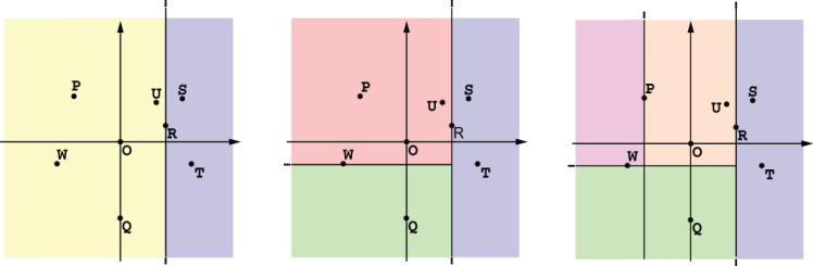
Follow the successive vertical, horizontal, and vertical splits to see how a two-dimensional region becomes binary-tree partitions. section 9.2
More coordinates also change the cost and meaning of proximity. Computing a distance between d-coordinate points takes O(d) operations; assigning n points to k centroids over m k-means iterations takes O(mknd) time. In sufficiently high-dimensional, near-uniform data, nearest and farthest distances can become similar, making nearest-neighbor distinctions less useful. K-d trees likewise perform best in low- to medium-dimensional spaces rather than high-dimensional ones. section 12.2.3 section 12.2.2 section 9.5